11 Startups for Drone Mapping and Aerial Imagery


Table of contents

One way we keep our overworked and underpaid MBAs busy here at Nanalyze is to run predictive analytics exercises. This mainly consists of them wondering out loud what it would be like if movies from the 1980s were remade today, with the latest tech gadgetry inserted into key scenes. Take the classic “Revenge of the Nerds” scene where the geeks conduct a panty raid on the Pi Delta Pi sorority house, while also installing secret video cameras in some key locations, like the showers. You can imagine a 2017 Nerds remake where they deploy drones to carry out their juvenile hijinks. After all, in one sense, drones are really nothing more than flying cameras, right?
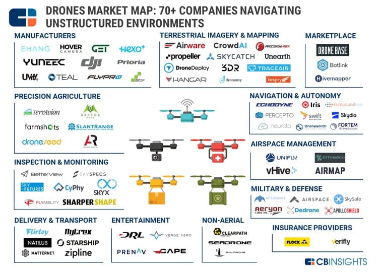
Not exactly, especially if we’re talking about commercial applications. In recent months, we’ve introduced you to seven startups developing drones for inspecting infrastructure and another half-dozen companies operating in different commercial and industrial niches, including ones that offer mapping and imagery services such as the well-funded Airware. Airware, in particular, is one of about a dozen companies that data firm CB Insights has identified as competing for business in the drone mapping sector.
These startups provide either hardware, software or both for drone platforms, especially for capturing, processing and even analyzing imagery. Construction and agriculture are among the main industries these startups target with their data intelligence. Let’s zoom in for a closer look.
3D Maps with No Credit Card Required
![]() Founded in 2013 and not to be confused with the 2012 James Bond movie “Skyfall,” San Francisco-based Skycatch has raised nearly $42 million from companies like Google and Qualcomm. Its customer list is equally impressive with names ranging from multinational engineering firm AECOM to Bechtel, the largest construction company in the United States. What does Skycatch do to fly in such rarefied air? While it builds a variety of its own drones, what really sets the company apart is its same-day precision drone mapping technology.
Founded in 2013 and not to be confused with the 2012 James Bond movie “Skyfall,” San Francisco-based Skycatch has raised nearly $42 million from companies like Google and Qualcomm. Its customer list is equally impressive with names ranging from multinational engineering firm AECOM to Bechtel, the largest construction company in the United States. What does Skycatch do to fly in such rarefied air? While it builds a variety of its own drones, what really sets the company apart is its same-day precision drone mapping technology.

Skycatch provides 3D topographical maps of an area down to the centimeter based on imagery from a drone flying a pre-programmed pattern. What’s it good for? Well, a company like Komatsu, a major manufacturer of construction and mining equipment out of Japan, uses that data to help direct robotic vehicles around work sites, according to Motherboard. Mapping plans start at $49 per month to $3,699 for high-res 3D. The platform supports multiple data types, as seen above. And, yes, there is a 30-day free trial. No credit card required.
![]() What’s better than a free trial? How about just free? Another company out of San Francisco that was also founded in 2013, DroneDeploy has picked up $31 million for its 3D drone mapping platform. DroneDeploy leaves the hardware to the world’s biggest drone maker, DJI. Users of its cloud-based platform can get limited access to functions like automated flying and image processing for free. Otherwise, plans range from $99 to $299 (or more for enterprise solutions). The company’s flagship product is its real-time Fieldscanner for agricultural intelligence that works without a cellular connection. DroneDeploy also serves other industries such as construction and mining.
What’s better than a free trial? How about just free? Another company out of San Francisco that was also founded in 2013, DroneDeploy has picked up $31 million for its 3D drone mapping platform. DroneDeploy leaves the hardware to the world’s biggest drone maker, DJI. Users of its cloud-based platform can get limited access to functions like automated flying and image processing for free. Otherwise, plans range from $99 to $299 (or more for enterprise solutions). The company’s flagship product is its real-time Fieldscanner for agricultural intelligence that works without a cellular connection. DroneDeploy also serves other industries such as construction and mining.
Update 11/13/2019: DroneDeploy has raised $35 million in Series D funding to expand internationally, move into new industries, and build out its suite of offerings for customers. This brings the company’s total funding to $91 million to date.
Out of Sight
![]() Raleigh-based PrecisionHawk does it all: drones, mapping, analytics, sensors, software and even consulting. The company has raised $29 million in disclosed funding since it was founded in 2011. Backers (as well as customers) include USAA, DuPont, and Yamaha, along with Intel and Verizon among others. At the helm, as of this year, is Michael Chasen, who founded edtech company Blackboard, which grew into a multinational company with more than 3,000 employees. No doubt PrecisionHawk hopes Chasen will pilot the company into new air space, as it expands globally.
Raleigh-based PrecisionHawk does it all: drones, mapping, analytics, sensors, software and even consulting. The company has raised $29 million in disclosed funding since it was founded in 2011. Backers (as well as customers) include USAA, DuPont, and Yamaha, along with Intel and Verizon among others. At the helm, as of this year, is Michael Chasen, who founded edtech company Blackboard, which grew into a multinational company with more than 3,000 employees. No doubt PrecisionHawk hopes Chasen will pilot the company into new air space, as it expands globally.
The company has an edge in that it is one of the only firms the FAA allows to pilot drones out of line of sight as part of a proof of concept phase. PrecisionHawk markets its own drones, especially a fixed-wing model called the Lancaster V (featured in the video above). Its PrecisionMapper platform competes against other drone mapping software like those peddled by Skyfall and DroneDeploy.
Update 12/12/2019: PrecisionHawk has raised $32 million in Series E funding to fuel the continued development of PrecisionHawk’s software offerings and the company’s sales and market expansion initiatives. This brings the company’s total funding to $136 million to date.
![]() Another competitor in the increasingly crowded drone mapping airspace is Silicon Valley startup Kespry. Founded in 2013, Kespry has raised about $28 million. It also covers a range of commercial applications, focused in industries like mining and construction. One of its clients, Whitaker Construction, says drone intelligence from Kespry helps it spend 22 percent less on jobs, while measuring their stockpiles twice as frequently and spending four times less time overall. Kespry also markets its tech to the insurance industry, especially for roof damage, which we can see being big business with the weekly Armageddon-sized storms and disasters hitting the world these days.
Another competitor in the increasingly crowded drone mapping airspace is Silicon Valley startup Kespry. Founded in 2013, Kespry has raised about $28 million. It also covers a range of commercial applications, focused in industries like mining and construction. One of its clients, Whitaker Construction, says drone intelligence from Kespry helps it spend 22 percent less on jobs, while measuring their stockpiles twice as frequently and spending four times less time overall. Kespry also markets its tech to the insurance industry, especially for roof damage, which we can see being big business with the weekly Armageddon-sized storms and disasters hitting the world these days.
Bringing AI into the Picture
![]() A young startup, founded just last year in Silicon Valley, CrowdAI raised $2 million in a Seed round to kick off the new year. It brings artificial intelligence and computer vision into the big picture by identifying specific objects in photos for its customers, with a human in the loop for quality control and to give feedback to the AI to improve the system. CrowdAI takes on not just drone imagery but data from satellites and even autonomous vehicles. TechCrunch notes that the startup’s main competitors are companies like Orbital Insight, which applies AI to satellite imagery.
A young startup, founded just last year in Silicon Valley, CrowdAI raised $2 million in a Seed round to kick off the new year. It brings artificial intelligence and computer vision into the big picture by identifying specific objects in photos for its customers, with a human in the loop for quality control and to give feedback to the AI to improve the system. CrowdAI takes on not just drone imagery but data from satellites and even autonomous vehicles. TechCrunch notes that the startup’s main competitors are companies like Orbital Insight, which applies AI to satellite imagery.
![]() At $6.5 million in raised capital, Austin-based Hangar Technology bills itself as the world’s first robotics-as-a-service data acquisition platform, which means that you hire it to do the flying (through a network of licensed pilots), data acquiring and AI-powered analyzing. Also founded in 2016, Hangar recently acquired Autoflight Logic, which “develops autonomous and semi-autonomous flight modes for DJI drones, enabling drone owners to execute flight and camera control sequences that were previously too difficult or impossible to perform manually.”
At $6.5 million in raised capital, Austin-based Hangar Technology bills itself as the world’s first robotics-as-a-service data acquisition platform, which means that you hire it to do the flying (through a network of licensed pilots), data acquiring and AI-powered analyzing. Also founded in 2016, Hangar recently acquired Autoflight Logic, which “develops autonomous and semi-autonomous flight modes for DJI drones, enabling drone owners to execute flight and camera control sequences that were previously too difficult or impossible to perform manually.”
The company services industries like construction, architecture and real estate. It recently launched a drone mapping service it calls JobSight to automate many of the tasks associated with construction such as surveys, site inspections and telling off-color jokes.
![]() Another fresh-faced startup that got off the ground in 2016, Seattle-based Unearth has dug up $1.3 million in a Seed round last December. Drones are only part of the picture for Unearth, which is developing what it calls construction collaboration software. It does this through a combination of drones, sensors, Internet of Things technology and artificial intelligence.
Another fresh-faced startup that got off the ground in 2016, Seattle-based Unearth has dug up $1.3 million in a Seed round last December. Drones are only part of the picture for Unearth, which is developing what it calls construction collaboration software. It does this through a combination of drones, sensors, Internet of Things technology and artificial intelligence.

The idea, according to GeekWire, is to “create a single place where construction workers in the field can communicate with teams in the office and gather accurate information that keeps projects on time and on budget.” We also counted at least three uses of the word isht on its website, so they know industry speak.
Also Up in the Air
As we said, drone mapping is becoming more competitive than midget sumo wrestling. Here’s a roundup of the rest of the market.
![]() Founded in 2014, Sydney-based Propeller Aero has raised about $4 million, including backing from top VC firm Accel Partners, which led a $3.1 million Series A a year ago. One of its flagship products is a piece of hardware called AeroPoints designed for ground control for drones, along with a software mapping program called Propeller.
Founded in 2014, Sydney-based Propeller Aero has raised about $4 million, including backing from top VC firm Accel Partners, which led a $3.1 million Series A a year ago. One of its flagship products is a piece of hardware called AeroPoints designed for ground control for drones, along with a software mapping program called Propeller.
![]() Founded in 2014, Botlink comes out of Fargo, North Dakota, with about $2 million in raised capital. Serving the agriculture and construction sectors, the company markets an app for flight control of DJI drones that can automate the takeoffs, landings, and everything in between. Its cloud-based software can turn drone imagery into cool maps that provide insight into crop health and where all of the wood chippers are located.
Founded in 2014, Botlink comes out of Fargo, North Dakota, with about $2 million in raised capital. Serving the agriculture and construction sectors, the company markets an app for flight control of DJI drones that can automate the takeoffs, landings, and everything in between. Its cloud-based software can turn drone imagery into cool maps that provide insight into crop health and where all of the wood chippers are located.
![]() Founded in 2015, Israeli startup Dronomy has raised $1.5 million in a Seed round last year. The company is focused on construction. Its selling point is turning off-the-shelf consumer drones into “powerful construction equipment, delivering the most precise and comprehensive construction site data.” Its real-time obstacle sensors also keep it from running into isht.
Founded in 2015, Israeli startup Dronomy has raised $1.5 million in a Seed round last year. The company is focused on construction. Its selling point is turning off-the-shelf consumer drones into “powerful construction equipment, delivering the most precise and comprehensive construction site data.” Its real-time obstacle sensors also keep it from running into isht.
![]() Founded in 2015, Silicon Valley-based TraceAir has picked up about $625,000 in a Convertible Note and Seed round. It provides a cloud-based platform to crunch data from drone imagery as well as a GPS rover. TraceAir focuses specifically on the earthworks project phase, helping clients with everything from estimating earthwork volumes to designing haul roads for the site.
Founded in 2015, Silicon Valley-based TraceAir has picked up about $625,000 in a Convertible Note and Seed round. It provides a cloud-based platform to crunch data from drone imagery as well as a GPS rover. TraceAir focuses specifically on the earthworks project phase, helping clients with everything from estimating earthwork volumes to designing haul roads for the site.
Update 01/20/2021: TraceAir has raised $3.5 million in Series A funding to go toward sales and marketing. This brings the company’s total funding to $6.9 million to date.
Conclusion
This is the point in the article where we tell you something profound, backed by market numbers that some MBA made up while watching reruns of the “Revenge of the Nerds.” So, to keep to tradition, Motley Fool estimates that “commercial drone market is expected to skyrocket to $23 billion annually by 2022, up from just $6 billion right now.” Does that include just drones? Or services? Or pilot salaries? Who knows. That’s why these market numbers are mostly drivel. We do know that drone mapping and aerial intelligence—whether for mining data on mining sites or surveying storm damage–is one of the sectors where the sky’s the limit. While one of these startups might IPO someday (we’re looking at you PrecisionHawk), you can get exposure to drone technology right now. Check out some of our previous content on drone investments here and here to get started.
Share