Orbital Insight Sees the Big Picture with AI


Table of contents

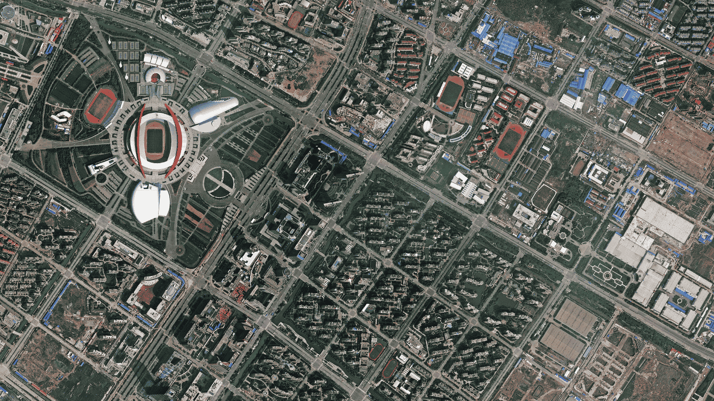
If you still think Google Earth is the coolest application of satellite imagery around, then we’re about to blow your mind.
It’s not just possible to see Dick Cheney’s house from outer space. Today, we can predict potential crop shortages and assess retail business during the holidays. We can learn which cities are the most dynamic and where poverty is hitting people the hardest.
Orbital Insight – Satellite Imagery and AI
How? All you need are millions of pictures from satellites orbiting the planet and a machine-learning algorithm able to detect objects and patterns from the imagery. A geospatial big data company called Orbital Insight is combining particularly powerful artificial intelligence wizardry with cloud computing to provide insights into economics, social issues, and conservation to help both investors and the planet.
About Orbital Insight
![]()
Before we blast off into all the cool stuff Orbital Insight can do, let’s take a look at its pedigree.
A Silicon Valley startup founded in 2013, Orbital Insight has received $28.7 million in funding since March 2015. The most recent round, a Series B last summer, took in $15 million, led by GV (formerly Google Ventures), along with the likes of top venture capital firm Sequoia Capital. An investment and development agreement from In-Q-Tel added another $5 million.
Update 11/13/2019: Orbital Insight has raised $50 million in Series D funding to accelerate product innovation and expansion of the company’s software solution, Orbital Insight GO. This brings the company’s total funding to $128.7 million to date.
CEO and founder James Crawford was, once upon a time, a lead scientist at NASA’s Ames Research Center. He’s had stints at several tech companies that were involved in high-dollar acquisitions, including a $1 billion buy-out of the Climate Corporation by Monsanto. He has also served as engineering director of Google Book Search, the rather modest project to scan, index and make searchable the world’s entire library of books.
Economic Indicators
Orbital Insight is a bit like Google Books but with a much bigger library of photos from which the company can tell many different stories. One of the more well-known examples of using satellite imagery has involved counting cars in store parking lots to determine customer flow, something we touched on briefly last year while discussing unstructured data. Today, Orbital Insight maintains its US Retail Traffic Index, which tracks more than 90 major retailers, providing snapshots of particular companies or the overall health of the U.S. retail economy.
A recent, high-profile example involved calculating China’s above-ground oil reserves using AI techniques like machine learning and computer vision. In this case, Orbital Insight’s computer algorithms can not only identify oil tanks but they can measure their capacity in order to calculate overall supply. As the company explained in a blog post last year: “The volume of the oil is visible because the tanks have floating roofs. Using our shadow detection techniques, we can gauge the size of the crescent-shaped shadow on the roof and calculate how full it is.” Using pictures from space no less.
Orbital Insight first tested the algorithm against the oil supply in the United States, which is relatively well known. It got within about 8 percentage points of the 300-week average. The algorithm even spotted a significant drop in supply last August, two days ahead of a report by the U.S. Department of Energy that sent crude oil prices significantly higher. This is the kind of data that can help you corner the frozen orange concentrate market.
But we digress: In China, which is strangely secret about its oil reserve, data are scarce. But not to the eyes in the sky. Orbital Insight’s algorithm identified more than 2,100 strategic and commercial petroleum reserve tanks capable of storing 900 million barrels of oil, quadruple the official number of tanks on record. As the company noted, “[T]hese findings have already dramatically changed our understanding of the amount of oil that can be stored in China, which gives investors the opportunity to price oil based on a more realistic estimate of supply.”
Social Signals
A bird’s eye view of the global economy isn’t Orbital Insight’s only trick. In addition to more than 60 asset management firms and several U.S. government agencies, Orbital Insight works with two global non-profit organizations: The World Bank and the World Resources Institute. We like to see this do-gooder side of the companies we profile. Sure, the technology is cool and there is money to be made, but without some social responsibility, it’s really just greed. Hopefully, you agree. Otherwise, there’s always Jim Kramer.
A review of a project Orbital Insight did with the World Bank will illustrate a bit more about the different ways the company leverages its satellite imagery to produce novel data. In this case, the World Bank wanted a different way to estimate poverty and economic activity from the timely and costly process of an on-the-ground census. Orbital Insight mapped several economic “signals” including buildings, building height, car density and agricultural land from satellite images of Sri Lanka. Car density, for example, can indicate which neighbors are more prosperous. Building density and height are variables correlated with development, and so on.
The satellite data proved invaluable: The imagery alone was able to account for about 60 percent of the variation in local poverty rates within small geographic areas and about 65 percent of the variation in the welfare of households living in those areas. The project was so successful that it’s being repeated in Mexico.
Billion-dollar Market
Orbital Insight isn’t the only company using AI to extract valuable information from satellites and drones, but it’s probably the leader in its class. CB Insights selected it for the Artificial Intelligence 100 list at the recent Innovation Summit. It’s been named a Technology Pioneer by the World Economic Forum. It has partnerships with the companies reputedly operating the five largest commercial satellite constellations in the world: DigitalGlobe, Airbus, Planet Labs, Rapid Eye, and Urthecast. It seems to have a particularly cozy relationship with DigitalGlobe (NYSE:DGI), which provides Orbital Insight access to more than 80 petabytes of imagery in the DigitalGlobe image library.
The market for commercial satellite imagery is expected to remain strong. Last year, Allied Market Research pegged compound annual growth in the double digits (11.5 percent) through 2022, hitting $5.275 billion in the next five years. Military dollars are expected to dominate still, but the launch of DigitalGlobe’s newest satellite, WorldView-4 last November, signaled that commercial interest is growing.
The Competition
A couple of companies competing with Orbital Insight includes another Silicon Valley startup, Spaceknow, and Descartes Labs of Los Alamos, New Mexico. However, both are more niche in their application of artificial intelligence to produce data from satellite imagery.
Descartes Labs was also among the lucky 100 winners in CB Insights top AI companies. It has taken in $8.28 million from three rounds of funding, the most recent coming from a $5 million Series A in November 2015. So far, its machine-learning platform has primarily been used in agriculture to forecast corn and soy yields, but the company says the algorithms can be used for many other applications.
Founded in February 2014, Spaceknow offers several different products and services, including what it calls its China Satellite Manufacturing Index. The SCMI tracks 6,000 industrial facilities in China with satellite imagery to monitor changes that indicate economic activity, such as new construction. Sounds a wee bit like spying to us. Besides, just head down to your local Wal-Mart store and look at the “made in” label if you want a quick snapshot of China’s economic machine. (Incidentally, Orbital Insight has a similar product, the China Economic Index.)
Still, it’s not hard to see that a satellite picture is worth … well, billions.
Share